
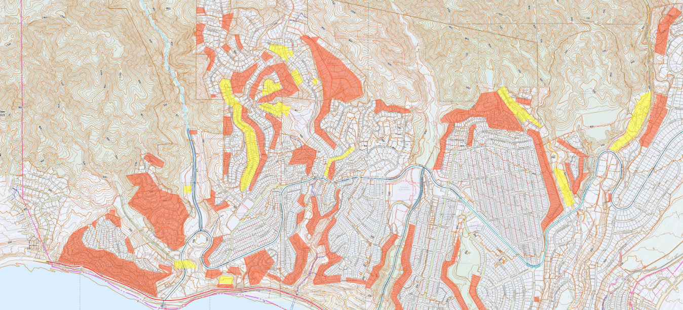
Palisades Geohazard Risk Assessment Zones
Guidance for homeowners navigating reconstruction after the 2025 fires from insurance coordination through permitting and construction.
If you're rebuilding a fire-damaged home in Pacific Palisades, one of the first things you need to determine is whether your property falls within a Palisades Geohazard Risk Assessment Zone (PGRAZ). If it does, your project requires a geotechnical investigation and Grading Division approval before a building permit can be issued. That process adds 8 to 16 weeks (or more) to your timeline and $15,000 to $40,000+ in investigation costs alone. Beyond the investigation, PGRAZ designation is a strong indicator that your rebuild will require more sophisticated and more expensive construction: deep foundations (caissons or drilled piers) instead of conventional footings, engineered retaining walls, slope stabilization measures, and specialized drainage systems. These are not optional upgrades. They are the geotechnical engineer's recommendations for building safely on your specific site, and they become conditions of your permit. The geotech report drives every downstream decision about foundation type, structural design, site grading, and construction sequencing. Understanding PGRAZ early is not optional. It determines what you can build, how much it costs, and how long it takes.
PGRAZ zones were created by LADBS after the January 2025 Palisades Fire to identify geologically sensitive properties within the fire area. The fire destroyed over 6,800 structures across more than 23,000 acres, many of them on hillside lots with documented slope instability, debris flow paths, or unstable soils. The City has streamlined permitting under the Emergency Executive Orders, and plan check timelines have been significantly reduced. But PGRAZ geotechnical requirements cannot be expedited or waived. They exist because the underlying geology demands them. For the full picture of what a fire rebuild involves beyond PGRAZ, including insurance gaps, construction cost ranges, the 110% threshold, and home hardening, see our comprehensive Los Angeles fire rebuild guide.
For homeowners whose properties were destroyed in the Palisades fire, PGRAZ adds a layer of complexity that standard fire rebuild guidance does not cover. The property may look like a cleared lot ready to build on, but the hillside beneath it has its own set of active conditions: slopes that may not meet current stability requirements, soils whose behavior has changed since the fire, drainage patterns that no longer function as designed, and debris flow exposure that didn't exist when the original home was built. Rebuilding on a PGRAZ site is not a standard fire rebuild with a geotech report attached. It is a geotechnical project, a structural project, a grading project, and a permitting project that all have to be sequenced and coordinated as a single process. The investigation comes first because it determines everything else.
Last updated: July 6, 2026. PGRAZ requirements, permitting timelines, and rebuild statistics are actively evolving. This page will be updated as conditions change.
- What PGRAZ Is & Why It Exists
- Understanding PGRAZ Zone Designations
- Geology of Pacific Palisades
- How Fire Changes Hillside Conditions
- Report Requirements by Zone
- Technical Thresholds & Code Requirements
- What the Combined Report Must Include
- Timeline Reality
- Cost Context for PGRAZ Rebuilds
- What Expedited Permitting Doesn't Change
- Streamlined Compliance Options
- When Grading Permits Are Required
- California Seismic Hazard Zone Requirements
- Coastal Zone Considerations
- Notification Requirements
- Getting Started: First Steps
- Frequently Asked Questions
- Related LADBS Information Bulletins
What PGRAZ Is & Why It Exists
PGRAZ stands for Palisades Geohazard Risk Assessment Zones, a specialized set of hazard overlay designations created by the Los Angeles Department of Building and Safety (LADBS) to identify geologically sensitive properties requiring enhanced geology and soils engineering analysis before rebuilding can occur.
The PGRAZ map was published following the January 2025 fire to provide a quick reference for determining if combined geology and soils reports will be required. Per P/BC 2026-157, PGRAZ zones are identified as geologically sensitive areas.
A mirror copy of the map (PDF) is hosted on this site for convenience; the LADBS version governs. You can also check your specific address via ZIMAS or LADBS Atlas.
Understanding PGRAZ Zone Designations
LADBS divides the fire-affected area into two primary hazard categories: Orange zones cover steep slopes and landslide-affected terrain, and Yellow zones cover sites at the bottom of slopes in debris flow and mudslide paths. Each triggers different report requirements and analysis scope. The zone determination is the first thing Benson Construction Group establishes on a Palisades rebuild, because consultant scope, foundation budget, and schedule all key off it.
Orange Zone vs Yellow Zone
- Combined geology and soils report (EG + GE)
- Grading Division approval before building permit
- Static slope stability analysis (FS ≥ 1.5)
- Seismic slope stability analysis (FS ≥ 1.0)
- Lateral earth pressure analysis
- Foundation recommendations per conditions
- Grading permit (separate from building permit)
- Combined geology and soils report (EG + GE)
- Grading Division approval before building permit
- Debris flow/mudflow hazard assessment
- Drainage and mitigation design
- Foundation recommendations per conditions
- Impact/diversion wall design (min. 3 ft height)
- Channel capacity analysis (10 cfs/acre min.)
Geology of Pacific Palisades
Understanding why PGRAZ requirements exist requires understanding the geology that makes Pacific Palisades inherently challenging for hillside construction. The area's dramatic terrain comes with significant geotechnical constraints that have caused problems for decades, long before the 2025 fire.
Bluff Formations & Composition
Pacific Palisades bluffs extend 50-150 feet above the beachfront with slopes ranging from 45 to 90 degrees. The geological layers present particular challenges for construction and stability.
Documented Landslide History
Pacific Palisades has one of the most significant landslide histories in Los Angeles County; the USGS mapped the area's landslide deposits in detail in Map MF-471 (McGill, 1973). Between 1911 and 2012, more than 30 road-closing slides occurred within three miles of coastline. Pacific Coast Highway has been rerouted at least five times due to landslide activity.
This history is precisely why PGRAZ requirements exist. The January 2025 fire removed stabilizing vegetation across thousands of acres, temporarily increasing erosion and debris flow risk. The underlying geologic hazards haven't changed. If anything, they're elevated in the short term.
Coastal Bluffs: Castellammare and the PCH Corridor
Properties along the Castellammare bluffs, Corona del Mar, and the PCH corridor face a distinct category of geotechnical challenge. Coastal bluffs in Pacific Palisades rise 50 to 150+ feet above the shoreline with near-vertical faces in many areas. These bluffs are actively retreating. The lower cliff face is composed of relatively erosion-resistant marine formations, but the upper portion consists of poorly consolidated terrace deposits (silty to clayey sands over cobble conglomerate) that erode readily when saturated or undermined.
Coastal bluff stability analysis differs from standard hillside slope stability in several important ways. The California Coastal Commission requires that development on bluff-top properties demonstrate structural stability for a minimum 75-year economic lifespan without requiring protective devices (such as seawalls) that would alter natural landforms, per Coastal Act Section 30253. This means the geotechnical analysis must project bluff retreat rates over 75 years and establish setback lines accordingly.
The development setback on a coastal bluff is established at the line where the factor of safety reaches 1.5 (static) or 1.1 (pseudostatic/seismic), whichever line falls further landward from the bluff edge. This is determined through a combination of historical retreat rate analysis (using aerial photography, survey data, and LiDAR), slope stability modeling of the bluff face, and assessment of marine erosion at the toe. For Castellammare properties, the Coastal Commission has a long record of requiring detailed geotechnical studies before approving development, including documentation of ancient landslide features in the bowl-shaped terrain west of Los Liones Canyon.
How Fire Changes Hillside Conditions
The January 2025 fire did not create the geologic hazards in the Palisades. It amplified them. Understanding how fire alters hillside conditions explains why PGRAZ requirements exist, why the geotechnical investigation matters more after a fire, and why post-fire rebuilds face risks that pre-fire construction may not have encountered.
Soil Hydrophobicity
When fire burns through vegetation and organic material at high temperatures, it creates a water-repellent (hydrophobic) layer in the soil, typically 0.5 to 5 cm below the surface. This layer fundamentally changes how water moves through the ground. Instead of infiltrating into the soil as it did before the fire, rainwater sheets across the surface, concentrating runoff and dramatically increasing erosion potential. The practical result: drainage patterns that worked before the fire no longer function the same way. The geotechnical investigation must characterize current soil conditions, not assume pre-fire behavior.
Loss of Root Cohesion
Vegetation root systems provide measurable cohesion to slope soils. Fire destroys these roots, reducing the shear strength of surficial soils. This is one of the factors captured in the slope stability analysis: the soil strength parameters used in the analysis must reflect current post-fire conditions, which may be weaker than what previous reports documented. Root recovery takes years. During that window, slopes that were stable before the fire may not meet the required 1.5 factor of safety without remediation.
Debris Flow Risk
This is the most significant short-term hazard and the primary concern for Yellow Zone properties. USGS research confirms that wildfire can drastically increase the probability of debris flows in landscapes that were previously stable. Post-fire debris flows are fast-moving slurries of water, mud, rock, and vegetation triggered by short bursts of intense rainfall. They can be triggered during the very first storm after a fire. The combination of hydrophobic soils, denuded slopes, and concentrated runoff creates conditions where even moderate rainfall can mobilize massive amounts of material downslope. Published flume research (Journal of Geophysical Research: Earth Surface, 2022) measured peak impact forces on downstream barriers up to 80% higher when flows entrain water-repellent burned bed material. This risk persists for several years following a fire, decreasing as vegetation recovers. For properties in Yellow Zones, debris flow hazard analysis and mitigation design (impact walls, diversion structures, drainage capacity) are required elements of the combined geology and soils report.
Report Requirements by Zone
The following table summarizes what's required based on your property's PGRAZ designation. Properties not identified on the PGRAZ list are typically on relatively flat terrain and may not require combined reports, though soils reports may still be required for specific excavation conditions.
| Requirement | Orange Zone | Yellow Zone | Outside PGRAZ |
|---|---|---|---|
| Combined Geology & Soils Report | Required | Required | Typically not required; soils report if excavating deeper than 5 ft or removing lateral support |
| Grading Division Approval | Required | Required | If grading permit required |
| Static Slope Stability (FS ≥ 1.5) | Required | If applicable | If slopes > 2:1 |
| Seismic Slope Stability (FS ≥ 1.0) | Required | If applicable | If in State hazard zone |
| Debris Flow / Mudflow Analysis | If applicable | Required | If in drainage path |
| Seismic Hazard Evaluation | Required | Required | If in State hazard zone |
| Grading Pre-Inspection (GPI) | Not required (reports mandatory) | Not required (reports mandatory) | Required in hillside areas |
| Self-Certified Compaction | Not allowed | Not allowed | Allowed (civil/geotech engineer) |
| Grading Permit | Required | Usually required | See exemptions |
Technical Thresholds & Code Requirements
The following technical thresholds are derived from LADBS Information Bulletins and the Los Angeles Building Code. Understanding these values helps contextualize what geotechnical reports must demonstrate.
| Requirement | Value | Reference |
|---|---|---|
| Seismic slope safety factor | ≥ 1.0 | P/BC 2026-049 |
| Static permanent slope safety factor | ≥ 1.5 | P/BC 2026-049 |
| Static temporary slope safety factor | ≥ 1.25 | P/BC 2026-049 |
| Retaining wall sliding safety factor (no EQ) | ≥ 1.5 | LABC 1807.2 |
| Retaining wall overturning safety factor (no EQ) | ≥ 1.5 | LABC 1807.2 |
| Retaining wall safety factor (seismic) | ≥ 1.1 | LABC 1807.2 |
| Hillside building slope threshold | 1:3 (33.3%) | LABC 1613.9 |
| Steep slope threshold | 2:1 (50%) | LABC 7014.1 |
| Seismic hazard return period (slope stability) | 475-yr (10% in 50 yr) | P/BC 2026-049 |
| Seismic hazard return period (liquefiable soils) | 2,475-yr (2% in 50 yr) | P/BC 2026-049 |
| Mudflow channel capacity | 10 cfs/acre (or 400 cy/acre storage) | LABC 7014.3 |
| Retaining wall height for geotech report | > 6 feet | P/BC 2026-083 |
| Impact/diversion wall minimum height | 3 feet | P/BC 2026-113 |
| Impact wall lateral design pressure | 125 psf/ft depth | P/BC 2026-113 |
| Engineered grading threshold | > 5,000 cu yd | LABC 7006 |
| Slope failure height trigger (slough protection) | > 20 ft vertical | LABC 7014.2 |
| Max R-value (hillside seismic design) | 5.0 | LABC 1613.9 |
| Minimum compaction | 90% (ASTM D-1557) | LABC 7011.3 |
What the Combined Geology & Soils Report Must Include
Per P/BC 2026-113, reports submitted to the Grading Division must be prepared by both a licensed Engineering Geologist (EG) and a Geotechnical Engineer (GE) or Soils Engineer. The report represents a substantial technical undertaking, not a checkbox exercise.
Site Investigation
Field exploration including test borings and/or test pits to characterize subsurface conditions. Detailed logs showing soil types, sampling depths, blow counts, and groundwater observations. For hillside sites, exploration must follow P/BC 2026-068 requirements for hillside exploratory work. The geotechnical map and cross sections must clearly show site boundaries, location of all exploratory excavations, earth material contacts, and extent of proposed grading work.
Laboratory Testing
All testing must be performed by an LADBS-approved laboratory. Required tests typically include grain size analysis, moisture content, density testing, shear strength testing, and consolidation testing as applicable. Shear test graphs must include sample location, soil description, moisture content, dry density at time of shearing, shearing rate, type of test (undisturbed or remolded), and resulting cohesion and friction angle. Material testing for slope stability analysis must follow P/BC 2026-049 requirements.
Engineering Analysis
Site-specific analysis requirements based on conditions:
- Static slope stability: Required for slopes steeper than 2:1 or where adverse geologic conditions exist. Minimum factor of safety 1.5 for permanent slopes, 1.25 for temporary slopes. All analyses must use saturated shear test data.
- Seismic slope stability: Required for sites with landslides or within State-mapped Seismically Induced Landslide Seismic Hazard Zones. Minimum factor of safety 1.0. Analysis per CGS Special Publication 117.
- Liquefaction analysis: Required for sites in State-mapped Potentially Liquefiable Seismic Hazard Zones. Per P/BC 2026-151 guidelines.
- Lateral earth pressure analysis: Required for retaining structures over 6 feet or surcharged by structures. Seismic lateral pressures required for walls exceeding 6 feet. Minimum seismic coefficient = ½ × ⅔ × PGAM.
- Settlement analysis: Required where differential settlement exceeds ¼ inch.
- Mudflow/debris flow analysis: Per LABC 7014.3 and P/BC 2026-113 where site is in concentrated drainage path.
- Bulking and shrinkage factors: Required for projects in hillside grading areas to determine actual export/import volumes.
Foundation Recommendations
The report must provide recommendations for foundation type, allowable bearing capacity, minimum embedment depths, setbacks from slopes (per LABC 1808.7.1), drainage requirements, and construction sequencing. These parameters become the basis for structural engineering design. The structural engineer cannot complete foundation design without them. For fire rebuilds where the existing foundation may be reused, a separate foundation certification process is required to confirm the existing system is in satisfactory condition and compatible with the geotech report's recommendations.
Timeline Reality: What "Expedited" Actually Means
Mayor Bass's Emergency Executive Orders have accelerated plan check review. The first permit was issued 57 days after the fire started, faster than the Camp and Woolsey fires. LADBS has targeted plan check completion within 30 days, and the City reports significantly reduced review timelines for standard rebuilds.
But the geotechnical investigation and Grading Division approval happen before plan check completes and operate on their own timeline.
| Duration | Activity |
|---|---|
| 2-4 weeks | Engage geotechnical consultant - Schedule field work, coordinate site access, mobilize drill rig. Post-fire demand has extended lead times for qualified firms. |
| 1-2 weeks | Field investigation - Test borings, sampling, geologic mapping. Hillside access constraints and terrain complexity can extend this phase. |
| 2-3 weeks | Laboratory testing - Shear tests, density, moisture, consolidation. Must use LADBS-approved laboratory. |
| 2-4 weeks | Report preparation - Analysis, cross-sections, recommendations. Complex sites require more extensive analysis and documentation. |
| 2-6 weeks | Grading Division review - LADBS review and approval. Correction cycles add time. This cannot begin until report is complete. |
| 8-16+ weeks | Total before building permit can issue - This is the critical path for PGRAZ properties, regardless of plan check speed. |
For complex hillside sites with multiple slopes, landslide history, or challenging access, add time. Each Grading Division correction cycle adds 2-4 weeks. The report timeline is driven by technical scope and site conditions, not permit expediting programs. For a broader view of how construction timelines work on complex residential projects, see our construction timeline guide.
Field note, July 2026: On the PGRAZ projects Benson Construction Group has coordinated, the schedule variable owners most consistently underestimate is the Grading Division correction cycle. A report that follows the P/BC 2026-113 checklist exactly, with complete cross sections, lab data, and analysis output, tends to clear in fewer cycles than one that leaves the reviewer asking for supplements. We treat the consultant's submittal package as a managed deliverable, not a formality.
Cost Context for PGRAZ Rebuilds
Geotechnical investigation costs vary significantly based on site complexity, number of borings required, laboratory testing scope, and analysis requirements. For PGRAZ properties, expect costs toward the higher end of these ranges. These costs are for investigation and reporting only, separate from recommended remediation.
| Investigation Type | Typical Range | Notes |
|---|---|---|
| Basic soils investigation (flat site, non-PGRAZ) | $3,000 - $6,000 | Limited borings, standard tests |
| Combined geology/soils report (PGRAZ zone) | $8,000 - $15,000 | Full EG + GE scope |
| Complex hillside investigation (steep slopes, multiple borings) | $15,000 - $25,000+ | Extended analysis required |
| Sites with landslide history or known instability | $20,000 - $40,000+ | Back-calculation, extensive testing |
| Neighboring property joint investigation (per property) | $6,000 - $12,000 | Shared mobilization costs |
Full Reconstruction Costs
Beyond the investigation, PGRAZ properties often require foundation systems and site improvements that significantly exceed standard flat-lot construction:
- Full home reconstruction: Varies significantly by size, finish level, and site complexity. Custom homes in Pacific Palisades typically range from $800-$1,200+/SF; PGRAZ hillside sites trend toward the higher end due to foundation and site work requirements.
- Hillside site work (caissons, soldier piles, retaining walls, shoring): $200,000 - $1,000,000+ depending on slope conditions, depth to bearing, and number of retention systems required
- Design, engineering, permits: Additional 15-20% of construction costs
- Total permitting costs (all technical reports): $70,000+ reported by some residents
- Foundation reuse (if feasible): Where an existing foundation can be certified as satisfactory by a licensed SE, this can reduce foundation costs substantially. The geotech report determines whether reuse is viable given current slope stability and site conditions.
One cost item has been suspended: under Mayor Bass's Emergency Executive Order No. 7, City permit and plan check fees are not being collected for eligible wildfire rebuilds (details and application at LADBS). In February 2026 the City Council voted unanimously to direct preparation of an ordinance making the waiver permanent and expanding it beyond single-family homes; until that ordinance is adopted, the suspension under EEO7 continues. Geotechnical investigation, engineering, and consultant costs are private-market costs and are not affected by the fee suspension.
What Expedited Permitting Doesn't Change
Current as of July 2026.
The City's streamlined fire rebuild programs have reduced permitting times significantly for standard rebuilds. Under EEO1, CEQA requirements are waived, discretionary processes are eliminated, and plan check is targeted for 30 days or less. Over 70% of single-family permit clearances are no longer required.
But PGRAZ properties aren't standard rebuilds. The expedited programs don't eliminate:
- Combined geology and soils reports reviewed by LADBS Grading Division
- Grading permits separate from building permits
- Foundation designs that respond to site-specific geotechnical recommendations
- Slope stability analysis or debris flow assessment depending on zone
- Grading Division inspections during construction
- 30-day written notice to adjacent property owners for deep excavations
- Grading bonds per LABC 91.7006.5
The same holds for the City's pre-approved options: a design from the Standard Plan Pilot Program shortens plan check, but on a PGRAZ lot it still requires the combined geology and soils report, Grading Division approval, and a site-specific foundation design responding to the geotechnical recommendations.
These requirements exist because the underlying hazards haven't changed. A fire doesn't stabilize a slope or redirect a debris flow path. If anything, the loss of vegetation increases short-term erosion and debris flow risk until regrowth occurs. This is why Benson Construction Group builds PGRAZ schedules around Grading Division review rather than around the expedited program timelines: the programs move plan check, and plan check was never the constraint on these lots.
Streamlined Compliance Options
Current as of July 2026.
LADBS has built in several provisions specifically to reduce time and cost for fire rebuild projects. Understanding these options can accelerate your timeline significantly.
Reusing Previously Approved Reports
Per P/BC 2026-157, if your property has an existing geology and/or soils report with LADBS approval dated within 10 years of the Mayor's EEO1 (January 2025), that report may be used for the rebuild if the scope is similar. Reports approved prior to the 2019 California Building Code will need updates for current seismic design parameters including seismic slope stability analysis and seismic lateral earth pressures.
Reports older than 10 years may still be used if the consultant can justify their validity. The consultant must provide a statement accepting responsibility for the prior data. Existing reports can be requested through LADBS Records. P/BC 2026-157 also allows previous remedial repairs, including existing foundation or slope improvements, to remain in place where the geotechnical consultants determine there is no potential instability.
Using Adjacent Property Reports
Existing reports for adjacent or nearby properties may be used to reduce new exploration if the area is geologically comparable. The new consultant must review, concur with, and assume responsibility for data from the prior report. This is particularly relevant where multiple neighboring properties were destroyed, and shared geotechnical studies can significantly reduce per-property costs.
Compaction Self-Certification (Outside PGRAZ Only)
For properties NOT in Orange or Yellow PGRAZ zones, soil compaction may be self-certified by a licensed civil or geotechnical engineer rather than requiring Grading Division approval. Both a subgrade observation memorandum and compaction report must be submitted to the LADBS Residential Inspector (BMI) for record keeping.
Plans must include the note: "The compaction report and observation of the subgrade will be self-certified by the consulting licensed civil/geotechnical engineer." The plan check engineer will verify the project is not within the PGRAZ.
Plan Self-Certification Program (PGRAZ Properties Excluded)
Separate from compaction self-certification, the City operates a plan-level Self-Certification Pilot Program under Emergency Executive Order No. 6: a California-licensed architect, or since February 2026 a licensed Civil Engineer, may take responsibility for verifying code compliance, and the project skips the full LADBS plan check. City guidance is explicit that geologically sensitive properties do not qualify, which excludes PGRAZ lots. The program's implementation guidelines, revised March 2026, list any site wholly or partly within a Geologically Sensitive Area identified in P/BC 2026-157 as ineligible. Other departmental clearances still apply to participating projects. If your property is in an Orange or Yellow zone, plan for the standard review path: the combined report and Grading Division approval remain the controlling sequence.
Foundation Reuse
Per P/BC 2026-157, reusing the existing slab and foundation is permitted, provided a California-licensed Professional Structural Engineer or Architect evaluates the foundation system and affirms it is in satisfactory condition. Documentation including observations and tests must be submitted to LADBS for review. For a detailed walkthrough of the foundation certification process required for fire-damaged properties, see our dedicated guide.
For PGRAZ properties, additional geotechnical investigation may be required to assess whether foundation reuse is feasible given slope stability and debris flow considerations. Don't assume reusability without professional evaluation.
Old Fill Exemption (Pre-1963)
Building code section 91.7011.6 requires investigation of fills placed before April 25, 1963. However, per P/BC 2026-157, testing the old fill is not required for fire rebuilds if the consultant determines the fill and proposed foundation are suitable for reconstruction. This determination is at the soils engineer's professional judgment.
Existing Site Nonconformities
Per P/BC 2026-157, applying Building Code Section 91.7005.9, a rebuild is not treated as a new building for site-compliance purposes. Existing site conditions that do not conform to current standards may remain; the new residence itself must be designed and built to current Code.
When Grading Permits Are Required
A grading permit is required for any excavation, fill, or import/export of earth materials. However, several exemptions may apply that can simplify the process for qualifying projects.
Grading Permit Exemptions
Per P/BC 2026-157, a grading permit is not required if the work complies with any of the following:
- Self-certified compaction: Outside PGRAZ zones only, where compaction is certified by the consulting civil/geotechnical engineer.
- Shallow excavation: An excavation less than 2 feet in depth.
- Minor slope cuts: Where the remaining cut has less than 50% (45°) slope, doesn't exceed 50 cubic yards, and doesn't change existing drainage patterns.
- Minor fill: Fill less than 1 foot deep on natural terrain with slope flatter than 10%, not exceeding 50 cubic yards, and not changing drainage patterns.
- Hillside caissons/piles: Excavations in hillside areas for caissons or piles under buildings authorized by valid building permits.
- Non-hillside foundations: Excavations in non-hillside areas for basements, footings, caissons, piles, swimming pools, or underground structures authorized by valid building permits.
- Utilities: Excavations for wells, tunnels, or utilities that don't provide vertical or lateral support for buildings.
- Shallow hillside footings: May be waived by LADBS if the site is relatively level and excavation is entirely for footings/grade beams not exceeding 5 feet deep.
Soils Report Exemptions (Non-PGRAZ Only)
For properties NOT in PGRAZ zones, a soils report is not required when removing lateral support from an adjacent private property if the neighboring lot has no structures (including masonry walls) within 45 degrees from the bottom of the excavation, provided one of these methods is used:
- ABC Slot Cuts: Maximum 6 feet wide, 8 feet high. If sloughing or caving occurs, a soils report becomes required.
- Shoring: Designed for 30 pcf equivalent fluid pressure, maximum 12 feet high. If deflection exceeds 1 inch, additional support and a soils report are required.
Neighboring Property Joint Investigation
Per P/BC 2026-157, LADBS explicitly encourages neighboring properties to jointly commission one geotechnical firm. This is one of the most practical cost-reduction tools available to PGRAZ property owners. In practice, it works like this: two or more adjacent owners engage the same geotechnical consultant. The consultant performs shared field work (borings, geologic mapping) across both properties, reducing mobilization and drilling costs per property. The laboratory testing and analysis cover both sites. The deliverable is either a single combined report addressing both properties or coordinated individual reports that share the underlying field data.
The cost savings are meaningful. Mobilization of a drill rig is a fixed cost whether it drills two borings or six. Geologic mapping of a hillside is more efficient when done across multiple adjacent lots in one visit. The cost table in the cost section below shows typical per-property ranges of $6,000 to $12,000 for joint investigations, compared to $15,000 to $25,000+ for individual complex hillside investigations. The limitation is that properties must be geologically comparable. If one lot is on bedrock and the adjacent lot is on an ancient landslide deposit, the investigation scope diverges and the savings diminish. The geotechnical consultant will evaluate whether a joint approach makes sense for a specific pair of properties. Benson Construction Group raises the joint-investigation question with owners before either lot signs a consultant agreement, because the option narrows once one property has mobilized on its own.
California Seismic Hazard Zone Requirements
Properties in California Seismic Hazard Zones require additional evaluations for earthquake-induced ground failure. For broader context on seismic requirements for residential properties, see our seismic retrofit guide. These requirements apply in addition to PGRAZ requirements where zones overlap.
- Earthquake-induced slope stability analysis: Required for sites with landslides or in State-mapped Seismically Induced Landslide zones. Minimum factor of safety 1.0. Per P/BC 2026-049 and CGS SP 117.
- Liquefaction analysis: Required for sites in State-mapped Potentially Liquefiable zones. Per P/BC 2026-151 guidelines.
- Fault investigation: Required for sites in Alquist-Priolo Earthquake Fault Zones or City PFRSA (Preliminary Fault Rupture Study Areas). Per P/BC 2026-129.
Exemptions are defined in P/BC 2026-044. If the site has a previously approved report with valid seismic hazard evaluations, new investigation may not be required.
Coastal Zone Considerations
Current as of July 2026.
A substantial portion of Pacific Palisades falls within the California Coastal Zone, subject to the California Coastal Act and City's Local Coastal Program. Properties must also comply with applicable residential zoning requirements. For a detailed discussion of coastal construction requirements in this corridor, see our dedicated guide. PGRAZ requirements still apply in the Coastal Zone, and additional requirements may affect your project.
Emergency Executive Order 8 Provisions
- Extends streamlined review to zoning-compliant single-family rebuilds beyond the 110% like-for-like threshold covered by EEO1
- Waives local Coastal Act review processes for eligible projects, aligning with the Governor's Executive Order N-29-25 suspension of the Coastal Act and CEQA
- Eligibility conditions include compliance with objective zoning standards, no increase in the number of dwelling units, and location outside wetlands and environmentally sensitive habitat areas
Bluff Setback Eligibility Criteria (EEO8)
- Project built at least 10 feet from a canyon bluff
- Project built at least 25 feet from a coastal bluff
These distances are EEO8 eligibility criteria, not the buildable setback. Actual buildable setback on a coastal bluff property is typically greater, because the geotechnical stability analysis may place the 1.5 factor of safety line further landward. On Castellammare and PCH corridor lots, the site-specific bluff retreat projection (75-year economic lifespan per Coastal Act Section 30253) combined with the slope stability setback can reduce the buildable footprint well beyond what the zoning setbacks alone suggest. See the coastal bluffs discussion in the geology section above for how this analysis works.
Separately, the City screens rebuild sites for bluff hazards. Check the Coastal Bluff Potential and Canyon Bluff Potential fields for your parcel in ZIMAS (under the Additional tab); if either shows Yes, City Planning ([email protected]) determines whether additional analysis is required before your project proceeds.
When Full Coastal Review Applies
Projects exceeding 110% of original size may require full Coastal Development Permits with additional review time. Properties in Palisades Highlands are subject to Coastal Development Permit No. A-381-78 (issued 1979) and must comply with adopted conditions. Contact California Coastal Commission South Coast District: [email protected] or (562) 590-5071.
Notification Requirements
Current as of July 2026.
Adjacent Property Notice (30 Days)
Per LAMC 91.3307.1, for excavations deeper than the foundation of an adjoining building and closer to the property line than the excavation depth, a 30-day written notice to adjacent property owners is required before permit issuance. Notice must be by certified mail, return receipt requested, stating the depth and timing of excavation. See P/BC 2026-060.
Hillside Project Notice (Suspended)
For hillside projects exceeding 500 SF of floor area or 1,000 cubic yards of grading, the standard 10-day mailed notification requirement under LAMC 91.106.4.6.1 has been suspended under Mayor Bass's Emergency Executive Order No. 8. However, posting on the property is still required.
Getting Started: First Steps for PGRAZ Properties
- Check your PGRAZ zone classification. Use the official LADBS PGRAZ map (published on the LADBS Forms & Publications page; search PGRAZ) or ZIMAS to determine whether your property is in an Orange Zone, Yellow Zone, or outside PGRAZ. This single determination shapes everything that follows.
- Engage a geotechnical consultant early. This is the longest lead-time item on your project. Post-fire demand for qualified firms is high, and the investigation-to-report cycle takes 8 to 16+ weeks. Starting this before or alongside architectural design, not after, keeps the geotech investigation off the critical path.
- Check for existing approved reports. Search LADBS Atlas or request grading documents through the LADBS Records Section for previously approved geology and soils reports on your property. Reports with approval letters dated within 10 years of January 2025 can often be reused, potentially saving weeks and thousands of dollars. See the streamlined compliance section for details.
- Coordinate with neighbors. If adjacent property owners are also rebuilding, a joint geotechnical investigation can reduce per-property costs significantly. This works best when initiated early, before either party has independently engaged a consultant.
- Understand the budget implications before committing to a design scope. PGRAZ compliance adds real cost: the investigation itself, plus whatever the report recommends (which may include caissons, retaining walls, slope remediation, or specialized drainage). Insurance replacement cost estimates rarely account for these items. Knowing the geotechnical reality before locking in a design budget prevents the most common source of cost surprises on hillside rebuilds. See our construction cost guide for current ranges. If you are evaluating a PGRAZ lot for purchase rather than rebuilding one you own, see our lot due diligence guide.
For information on how BCG manages fire rebuild projects in Los Angeles, including PGRAZ compliance, foundation certification coordination, and full reconstruction delivery, see our Fire Rebuild Contractor page.
For information on how BCG approaches hillside construction on residential projects in Los Angeles, including shoring coordination, deep foundation sequencing, and multi-agency permitting, see our Hillside Home Builder page.
Frequently Asked Questions
LADBS maintains the PGRAZ map and address list, available through their website and via ZIMAS (Zone Information and Map Access System). You can also access maps through LADBS Atlas. Even if not on the PGRAZ list, properties in hillside areas may still require geological reports based on site-specific conditions discovered during plan check or grading pre-inspection.
Architectural design can proceed in parallel, but structural design requires the geotechnical recommendations. Starting structural work before the soils report is complete means the structural engineer is designing from assumptions rather than data. The geotechnical investigation should be initiated as the first step because it is on the critical path and drives the entire project schedule.
Yes. Per P/BC 2026-157, LADBS explicitly encourages neighboring properties to jointly commission one geotechnical firm to provide reports covering multiple properties. This reduces per-property costs for mobilization, drilling, and report preparation while meeting all requirements. The consultant addresses each property's specific conditions in a combined or coordinated report.
No. Emergency Executive Orders have accelerated plan check review and waived certain zoning and discretionary requirements, but geotechnical safety requirements remain mandatory. The combined geology/soils report must still be approved by the Grading Division before building permit issuance. The expedited pathway makes everything faster except the geotechnical work, which is driven by site conditions, not paperwork.
The report provides the basis for safe construction. If it recommends caissons, soldier piles, retaining walls, buttress fills, or slope stabilization measures, those become required elements of your project. Understanding this early, before committing to design or budget, matters more than any other single variable. A preliminary geotechnical assessment can identify major cost drivers before design is underway.
Reports approved within 10 years of the Mayor's EEO1 (January 2025) can generally be reused for fire rebuilds if the scope is similar. Older reports may be used with consultant justification and acceptance of responsibility. Reports approved before the 2019 California Building Code require seismic parameter updates for seismic slope stability and seismic lateral earth pressures.
Both sets of requirements apply. PGRAZ geotechnical requirements must be met, and Coastal Zone provisions also apply. Under EEO1, like-for-like projects within 110% of original size have streamlined pathways, and EEO8 extends streamlined coastal review to zoning-compliant single-family rebuilds beyond the like-for-like scope. Projects that qualify for neither may require full Coastal Development Permits with additional review time. Coordinate with both LADBS and the California Coastal Commission early in your planning.
Potentially. Per P/BC 2026-157, a California-licensed Structural Engineer or Architect must evaluate the foundation and affirm it is in satisfactory condition. For PGRAZ properties, additional geotechnical investigation may be required to assess feasibility given slope stability and debris flow considerations. Foundation reuse can save significant time and cost, but requires professional evaluation, not assumption. See our foundation certification guide for the full process.
PGRAZ properties require a coordinated team: Engineering Geologist (EG) for geology report and hazard assessment; Geotechnical Engineer (GE) for soils analysis and foundation recommendations; Structural Engineer for foundation and building design based on geotech recommendations; Architect for design and permit documents; and Civil Engineer for grading plans, drainage, and site work. A construction manager can coordinate the team and sequence work efficiently to minimize total timeline. On PGRAZ rebuilds, Benson Construction Group takes the construction manager seat in this structure, sequencing the consultants so the geotechnical work leads. For a broader view of assembling and managing a high-end residential project team, see our owner's guide.
Many fire insurance policies cover "like-for-like" replacement. PGRAZ requirements don't change what was destroyed. They affect what's required to rebuild safely. If your previous home was built to code at the time, your policy may cover rebuilding to current code. However, if geotechnical investigation reveals conditions requiring foundation systems beyond your original construction (deeper caissons, additional retaining walls, etc.), those costs may exceed coverage. Extended Replacement Cost coverage can help bridge gaps. Work with your adjuster to document scope requirements early and understand your policy limits.
In a six-month survivor survey, roughly 70% of Palisades and Eaton fire survivors reported insurance delays or denials. ClaimArchitect's analysis of Palisades claims found payouts running roughly $600 per square foot short of realistic rebuild costs, about $1.5 million on a typical home. State Farm had non-renewed about 1,600 Palisades policies, just under 70% of its policyholders there, before the fire. In May 2026 the California Department of Insurance took enforcement action against State Farm after finding nearly 400 claims-handling violations in a sample of 220 wildfire claims. While permitting has been significantly expedited under the emergency executive orders, insurance resolution is taking much longer and remains the primary financial barrier to rebuilding for most homeowners.
Through May 2026, 928 single-family rebuild permits had been issued in Pacific Palisades per the Pali Builds tracker, with 15 completed rebuilds holding certificates of occupancy; the first was issued November 21, 2025, for a developer-built home rather than a returning homeowner. Across all fire zones, LA County's Permitting Progress Dashboard tracks more than 12,000 rebuild projects, and single-family permits are being processed roughly three times faster than pre-fire baselines. The wide gap between permits and completions reflects the construction timeline for complex rebuilds, and PGRAZ properties sit at the long end of it because geotechnical work, foundation systems, and site work add months before framing can begin. Current figures update on the County dashboard, and our fire rebuild guide tracks the full current state of the recovery.
Both zones require a combined geology and soils report and Grading Division approval. The difference is the primary hazard being evaluated. Orange Zone properties are on or adjacent to steep slopes or landslide areas. The critical analysis is slope stability: can the slope support the proposed structure with the required factors of safety (1.5 static, 1.0 seismic)? Orange Zone sites typically require deep foundations (caissons or drilled piers) and may require retaining wall systems or slope stabilization. Yellow Zone properties are at the base of steep slopes, in debris flow and mudslide paths. The critical analysis is debris flow hazard: what volume and velocity of material could reach the site, and what protective structures are needed? Yellow Zone sites typically require impact or diversion walls (minimum 3 feet high), drainage capacity analysis (minimum 10 cfs per acre), and foundation design that accounts for potential debris impact loads.
This is common on hillside PGRAZ sites, and it doesn't mean you can't build. It means the geotechnical report must recommend remediation measures that bring the factor of safety up to the required minimum. Options include deeper or additional caissons to anchor through the unstable zone, soldier pile or sheet pile retaining walls to buttress the slope, removal and recompaction of unstable fill, subdrain systems to manage groundwater that reduces soil strength, or setback of the structure further from the slope face. Each solution has different cost and timeline implications. The geotech report specifies what's needed; the structural engineer designs it. This is the core reason the investigation must come before structural design, not after.
In PGRAZ Orange Zones, yes. A grading permit is separate from the building permit and follows its own review track through the Grading Division. In Yellow Zones, a grading permit is usually required. Outside PGRAZ, grading permits are required for excavations exceeding certain thresholds (generally over 5,000 cubic yards for engineered grading, though hillside areas require engineered grading regardless of volume per LAMC 91.7004). Several exemptions exist for smaller-scope work. See the grading permits section for the full list. The key point: if you need both a grading permit and a building permit, they are separate applications with separate review timelines. Plan for both.
Yes. To qualify for the EEO1 streamlined path, building permits must be obtained before January 13, 2032, seven years from the order's issuance, and construction must be completed within three years of permit issuance. EEO8 runs on a parallel clock: permits within seven years of its issuance in July 2025, with the same three-year completion window. For PGRAZ properties, the practical implication is to start the geotechnical investigation early enough that Grading Division approval does not consume the margin.
No. The City's plan-level Self-Certification Pilot Program, which lets a licensed architect or Civil Engineer verify code compliance without a full LADBS plan check, excludes geologically sensitive properties, and PGRAZ lots fall in that category. The compaction self-certification option under P/BC 2026-157 is likewise limited to properties outside the Orange and Yellow zones. On a PGRAZ lot, plan for the standard sequence: combined geology and soils report, Grading Division approval, then building and grading permits.
Related LADBS Information Bulletins
Current as of July 2026.
The following LADBS Information Bulletins contain detailed technical requirements relevant to PGRAZ rebuilds. Understanding these documents provides the foundation for navigating the approval process.
How We Help
Benson Construction Group provides Construction Manager at Risk (CMAR) services for complex residential rebuilds, including properties in PGRAZ zones. Our pre-construction involvement on hillside and fire rebuild projects includes:
- Identifying geotechnical requirements and timeline implications at project outset
- Recommending qualified geotechnical consultants experienced with LADBS requirements
- Coordinating geotechnical investigation with design schedule to avoid delays
- Reviewing report recommendations for constructability and cost implications
- Budgeting for recommended foundation systems, retaining walls, and remediation
- Navigating Grading Division approval process and correction cycles
- Sequencing grading, foundation, and building permits to minimize total timeline
- Providing realistic cost and schedule projections before design commitment
For fire-affected properties, early identification of geotechnical requirements and realistic timeline planning set the foundation for the entire project. The investigation phase drives everything that follows. This type of scope, coordinating the geotechnical investigation, permitting, foundation design, and construction execution around a fire-damaged hillside property, is what BCG structures as a focused engagement.
Fire-Damaged Foundation Certification →
Hillside Construction in Los Angeles →
Foundation Systems & Geotechnical →
Retaining Walls in Los Angeles →
Shoring & Underpinning in Los Angeles →
Coastal Construction in Malibu →
Seismic Retrofit in Los Angeles →
Construction Costs in Los Angeles →
Construction Timeline in Los Angeles →
Los Angeles Permitting Overview →
Grading Limits in Los Angeles →
Budget Development & Cost Control →
Feasibility Report →
Focused Engagement Options →
If you're rebuilding on a PGRAZ property and need to understand the geotechnical, permitting, and cost implications before committing to design, BCG can help define the scope and coordinate the process.
This page provides general information based on LADBS Information Bulletins, Los Angeles Building Code requirements, and professional experience as of the date shown. Regulations, requirements, and costs change. Verify all requirements with LADBS and your licensed professionals before making project decisions. Benson Construction Group is a California licensed general contractor, CSLB License #1007735.